Με αφορμή την πεντηκοστή επέτειο του μνημείου «Torres de Satélite», σχεδιασμένου από τον Luis Barragán και τον Mathias Goeritz (1958), το περιοδικό ARQUINE προκύρηξε διεθνή αρχιτεκτονικό διαγωνισμό Ιδεών προτείνοντας το σχεδιασμό ενός κέντρου τεχνών (FARO:Fabrica de Artes y Oficios) στην τοποθεσία του μνημείου. Το μνημείο, σύμβολο του μεξικάνικου μοντερνισμού αλλά και τοπόσημο της περιοχής Ciudad Satélite, είναι ένα σύνολο πέντε πρισμάτων τριγωνικής κάτοψης με ύψη από 30 ως 52 μέτρα. Οι «πύργοι», σχεδιασμένοι με στόχο την εμπειρία της θέασής τους από το αυτοκίνητο, σύμφωνα με τα ιδεώδη της εποχής της μηχανής, διαμορφώνουν μια πλατεία ανάμεσα στις λωρίδες κυκλοφορίας του περιφερειακού αυτοκινητοδρόμου. Σκοπός του διαγωνισμού ήταν να δημιουργηθεί ένας προσβάσιμος δημόσιος χώρος που να επαναπροσδιορίζει τον χαρακτήρα της πλατείας δίνοντάς της νέο περιεχόμενο και συνδέοντάς τη με την πόλη.
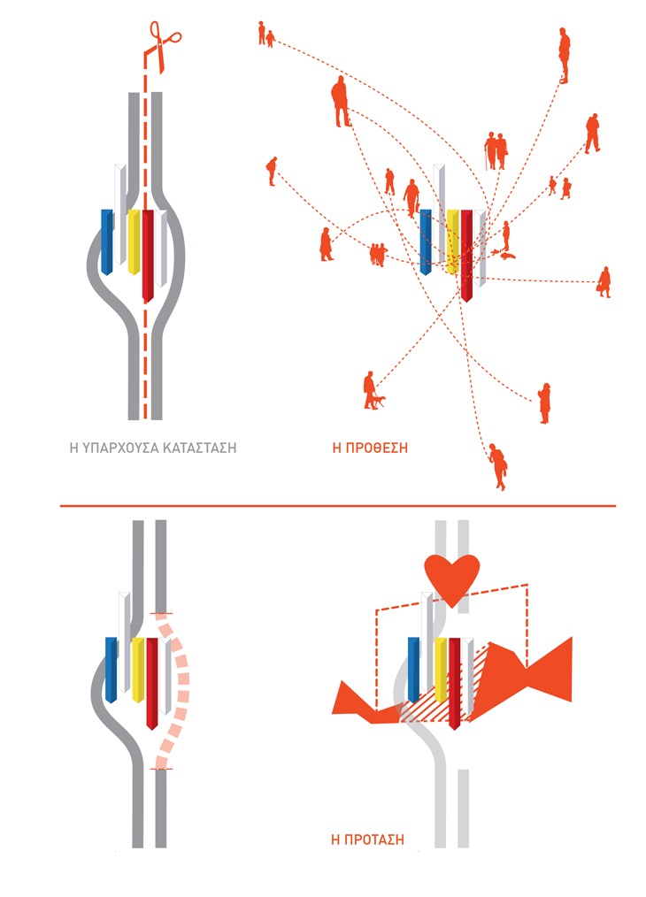
Η πρόταση αφορά σε μια παρέμβαση τοπιακής σχηματοποίησης μη-μνημειακού χαρακτήρα σε μια τοποθεσία που χαρακτηρίζεται από την ταυτότητα των «Torres de Satélite» ως μνημείου. Κεντρική σχεδιαστική προτεραιότητα αποτέλεσε η σύνδεση, διαμέσου του χώρου των πύργων, της διχοτομημένης από τον αυτοκινητόδρομο πόλης, μέσω της δημιουργίας ενός νεόυ δημόσιου χώρου σε δύο επίπεδα που να λειτουργεί ως βασικός κόμβος σε ένα δίκτυο ροών πεζών.
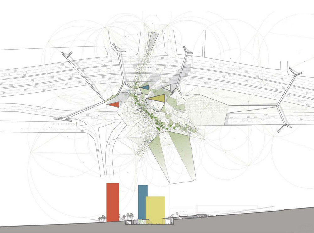
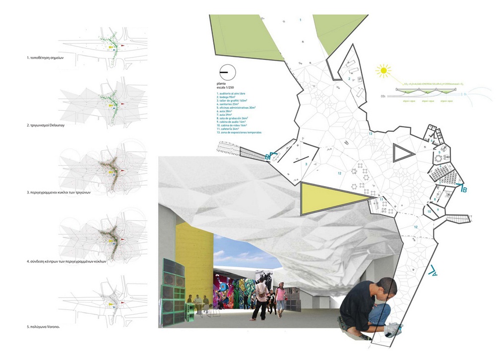
Βασικό μέσο για την οργάνωση ενός δικτύου συνδέσεων και για τον προσδιορισμό ενός νέου επιπέδου ανάγνωσης και επανεγγραφής της τοπικής ταυτότητας αποτέλεσε η διαγραμματική ανάλυση διαδρομών των πεζών μεταξύ βασικών κόμβων στην πλατεία. Αυτό το σύστημα διαδρομών οργανώθηκε γεωμετρικά μέσω της εφαρμογής ενός διαγράμματος πολυγώνων Voronoi για τον υπολογισμό ισαπεχόντων ορίων μεταξύ σημείων ενδιαφέροντος. Τα πολύγωνα ερμηνεύονται με πολλαπλούς τρόπους και εμφανίζονται με διαφορετικές εκφάνσεις σε όλα τα επίπεδα της πρότασης διαμορφώνοντας τα επιμέρους σχεδιαστικά συστατικά της.
Η πρόταση βρέθηκε στην 4η θέση και βραβεύτηκε με τον 1ο Έπαινο.
EN
Project by Paan architects in collaboration with Anna Lascari and Chrysokona Mavrou.
On the 50th anniversary of the monument «Torres de Satélite» designed by Luis Barragán and Mathias Goeritz, ARQUINE magazine organized an international architectural competition proposing to create a center of Arts & Crafts (FARO Fabrica de Artes y Oficios) in the base of the monument. The monument, being a symbol of Mexican modernism but also a landmark for the area Ciudad Satelite is a composition of five triangular volumes that range in height from 30 to 52 meters. The towers that were designed to be experienced from the car in movement, symbol of the machine age, they form a plaza in between the different flows of the motorway.
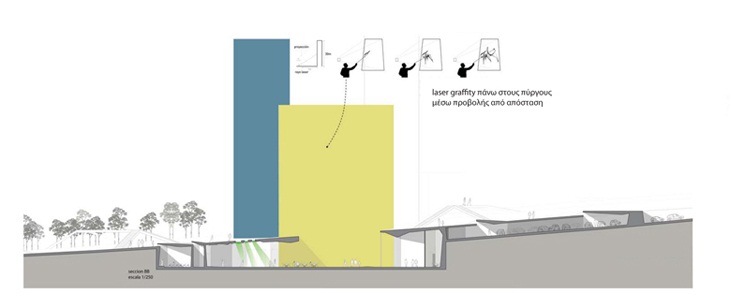
The proposed intervention consists of a territorial formation in a location that is characterised by the monumental identity of the “Torres de Satélite”. The major concern was to connect the city, currently divided by the motorway, through the space of the towers, generating a new non-monumental public space in two levels that would function as a principal node in a network of pedestrian flows. The organisation of a network of connections and the definition of a new manifestation of local identity is pursued through a diagrammatic analysis of the pedestrian routes between principal nodes on the square. This system of routes is organised geometrically through a tessellation of Voronoi polygons that define equidistant boundaries between points of interest. The Voronoi polygons are subjected to multiple interpretations to generate the design features that constitute the proposal.
The proposal got the fourth place in the competition and was awarded with the first mention.
 SITE PLAN AND SECTION
 SECTONB-B
 PLAN
PLAN CONCEPT
READ ALSO: The contemporary ruin: a manifesto / Architect Andreas Angelidakis